
If your Dad was a caver I would expect that he toured some of the lava tubes on the east side of the Cascades. There are several near the highway not far north of Klamath Lake, just South of Bend where the family likely turned west to head to Salem.


If your Dad was a caver I would expect that he toured some of the lava tubes on the east side of the Cascades. There are several near the highway not far north of Klamath Lake, just South of Bend where the family likely turned west to head to Salem.
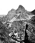
Jim Grave's nailed the scene from Klamath Lake with Mt McLoughlin in the background -- if you look at both of these images in Photoshop or something like that, the ridge lines and other features line up very closely (and they would be exact if the stand-point was the same for both images). This is a great example of how to really find a scenic photo location"so I suspected at least 1 of these photos was Mono Lake. So thanks for the confirmation about that."
The other scene, that is putatively of Mono Lake, is most likely not. I tried many vantage points from the shore of Mono lake in Google Earth (using the little man thingy) for "Street View", and can't even come close, or see how I can come close given what is in the background, for it to be Mono Lake. I could be wrong - give it a try if you really want to know. It could be an all day task to really find the true location, if the itinerary posted here is close to what your parents actually did. Using Google Earth is tedious, but it does confirm educated (or not so educated) guesses.
It's Mono Lake from the Hawthorne Road just north of the Lake. The island is unmistakable. Google Earth is really a poor tool is respect of interpreting landmarks. Old time stereo aerial photos are far far better for interpreting specific landforms, even today. But I've only been right past Mono Lake hundreds of times. As far as Klamath Lake goes, I utterly hate that road in the summer, all clogged with Motorhomes, logging trucks, etc. My late brother moved to Bend, so I had to take that route sometimes. When I was a kid my dad routinely took me out of school for two-week geology and rockhounding tours which often involved eastern Oregon. There are lava tubes all over the eastern Cascades. Captain Jack holed up in caves in Modoc Country (northern Cal) during the last official Indian war in this country, and the most expensive one, though minor skirmishes continued here n' there elsewhere in the state for at least thirty more years.
Google Earth is not perfect, but as Drew Wiley aptly demonstrates, human memory is an even worse tool for identifying landmarks and photo points. Jim Graves' post (#16) shows a close match between the original photo and Google Earth's version for the Klamath Lake scene. For the putative Mono lake scene, I tried various points along the Hawthorne Road in Google Earth, and nothing matches, including large features such as mountains, shoreline configuration, etc. (and I have been along the is road many times too, and thought Mono lake was a plausible choice). Anyone with Google Earth and access to the LFPF site can verify what I am saying, so I will not belabor this point.It's Mono Lake from the Hawthorne Road just north of the Lake. The island is unmistakable. Google Earth is really a poor tool is respect of interpreting landmarks.
They are better (I have made maps from aerial photographs, long before digital versions came about) if the resolution is high -- and it usually is -- for a bird's eye view, but converting them to an oblique view that shows topography as one would see it standing on the ground is very difficult and time consuming.Old time stereo aerial photos are far far better for interpreting specific landforms, even today
The imagery within Google Earth usually have a 1-meter or so ground resolution, so it does not resolve vegetation and other fine features very well, but larger features are quite accurately depicted.
Scientists are using Google Earth to re-locate historic photo points, and Thomas C. Hanks and others published a nice demonstration in "Repeat Photography: Methods and Applications in the Natural Sciences", edited by Robert Webb, Diane Boyd, and Raymond Turner. Many of their scenes were partially under the waters of Lake Powell, but they still could find the original locations using Google Earth and it saved them an enormous amount of time. It's one thing to drive along a highway looking around, and quite another scrambling around the canyon country of Arizona.
To me, it is a lot more fun to try and guess from memory where a photo was taken and then go there to check it out, and before Google Earth came about, I had done this many times and had been wrong many times. But here is an example where I "did not need no stinkin' Google Earth" to find the photo point. It also demonstrates the accuracy of Google Earth for identifying landmarks -- in this case the Grand Teton, a well-known landmark in Wyoming, and its environs.
The image on the left is William H. Jackson's, taken during the Hayden Survey of 1872 around July 28, the middle one is mine from June 22,2015, (on 4 by 5 Ilford Ortho Plus, no filter), and the one on the right is from Google Earth, Landsat Imagery from August 2, 2013, and a digital elevation model (DEM).
The approximate location for the photopoint is at 43 deg 44' 44.35", 110 deg 50' 44.78",10974 feet elev. "Table Mountain, Alta, WY" will get you close.

Jackson's photo point is on a small ledge, barely wide enough for me and the tripod, at the very brink of the steep couloir (gully) in the foreground. Just above it was a more spacious ledge but it was clearly not his spot, as the foreground elements did not line up from there. Google Earth is much too crude to find such an exact photo-point -- the elevation detail for digital elevation models (DEM) are usually based on USGS topographic maps, and here the contour interval is 80 feet. The DEM can distort the local topography, such as the pinnacle on the right foreground. So there are clearly limitations, but Google Earth can get you within 10 to 20 feet of the original photopoint if there are distinct foreground features. Without such features, topography in the background, even if miles away, can be used to get within say 100 feet of the photopoint in many cases.
Jackson's photo is remarkable in many ways, but two that stand out for me are:
1. The amazing clarity - the mountains in the far background (Gros Ventre's) are about 20 to 30 miles away, but show much more clearly than in my photo. Typically, distant features are faint to invisible on wet collodion emulsions when there was atmospheric haze. During my visit, there was some haze but it would take a totally blue-bird day to match what Jackson saw.
2. The photo-point -- Jackson writes about getting to this place as a harrowing experience. He would have crossed 35 to 40 degree snow, perched over large, steep cliffs, to even get near the photo point. Yet when he got there, he picked a dramatic, exposed ledge to set up his gear rather than a much safer spot nearby that would have served just as well. Such a choice is a window into William Jackson's personality.
For the geologists: Jackson's photopoint is at the lower boundary of the Flathead sandstone formation (middle Cambrian), which sits unconformably on Precmabrian gneiss and quartz monszonite here. There is a 2 billion-year gap in the rock record just below his feet.
This is fun stuff. Ironically, one of the worst photographers ever for landmark memory was AA. He repeatedly misidentified mountains, and some of those naming errors have passed on to relatively famous photographs. Where I find Google Earth particularly deficient is in reading vertical scale. You can have a three thousand foot cliff and it hardly shows unless there is a prominent shadow. With stereoscope photos, relief stands out dramatically. It's even easier to read relief on a conventional topo map than most Google Earth application, though they do have a kinda half-baked way to show shaded relief counters. I state this from a learning curve that goes way back to doing my own archaeological and geologic research exercises using aerial photos. But those old stereoscopes were sure hard on the eyes! It's how they spotted Germany's underground V2 bunkers, disguised tanks and ships etc during WWII. Labor intensive, but actually better in many ways than today's satellite images, which really act more like spotting scopes before analysts selectively home in on details. Yet it does amaze me how
the old surveyors got atop remote mountains decades before official "climbers" did. Wheel Mtn on the Black Divide in the Sierras is an example.
Google Earth is totally deficient the vertical dimension when in "bird's eye" view. It is akin to looking at a single aerial photograph rather than a stereo pair. But the vertical (topographic) aspect is very apparent and quite accurate when using the "street view" feature. The "Street view" involves moving the little man thing onto the image -- that is how I came up with the image of the Grand Teton etc. in thread #24. This approach is much more practical than using a topo map or stereo pair of photos when trying to identify a scene taken with a camera on the ground somewhere, which is the original topic for this thread.Where I find Google Earth particularly deficient is in reading vertical scale

First one, I do not know.
Second on looks like Mono Lake.
Nothing beats a great piece of glass!
I leave the digital work for the urologists and proctologists.
Thanks again for everybody's suggestions.
My sister and I have discussed our parents' trip, and we now feel that our parents went up Highway 97 from Yosemite to Salem, Oregon. So I was wrong about them driving up the California coast :-( We are continuing to discuss where the other photos were taken, but somewhere along Highway 97 (circa September/October 1962) seems to be the answer...
Happy New Year to everybody :-)
Namaste
Daniel


What Dorothy said, "There's no place like home."
with a computer...
Tin Can
Really very fascinating. Sincerely, Thank-you for this post....and nice work on finding Jackson's spot.Originally Posted by mmerig

 Posting Permissions

 Reply With Quote
Bookmarks